Although originally built for military purposes, unmanned aerial systems (UAS) have increasingly become a common part of everyday life. According to the Federal Aviation Administration (FAA), there were 865,505 drones registered in the United States as of May 31, 2022.1
Because of their wide range of functions, drones have been used to monitor climate change, deliver goods, and capture images and video. These capabilities have extended to the law enforcement profession as well.
Different Use Cases
The policing profession must constantly stay abreast of the emerging technology in the world. This becomes difficult as this new technology begins to have new (oftentimes beneficial) functions, exemplified by the drone.
“Drones are revolutionizing search and rescue, disaster response, crime scene mapping and modeling, tactical overwatch, and de-escalation, helping keep officers and the communities they serve safer,” said CJ Smith, category marketing manager for drones at Adorama Business Solutions.2 In many cases, drone operators have found useful ways to increase public safety.
Situational Awareness
In the past, officers may have lost track of suspects as they exited the home and searched for an alternate escape route. But with a drone hovering over the residential block, the drone is able to track the suspects as they jump fences and hide under bushes. The drone operator can then give the officers on the ground real-time updates on the suspects’ movements, leading to a safe, efficient arrest.
Autel Robotics has been a manufacturer of drones that provide this exact overwatch capability. “Since 2014, we’ve strived to let the needs of our customers drive innovation,” said Tommy Gunn, marketing manager of Autel Robotics USA. “With this goal in mind, we’ve developed key technologies, such as quadcopters and VTOL-capable fixed-wing drones with the flexibility of interchangeable camera payloads, long-range image transmission, and autonomous software for easy mission planning.”3
Along with its use for overwatch, the company’s consumer product family of EVO vehicles (EVO NANO series, EVO LITE series, and EVO II series) can help fulfill other missions. They can be used to observe suspicious vehicles and ensure buildings are clear before officers are sent in. They’ve also been used to monitor fire spread and direction—and firefighters in the field—especially when outfitted with thermal imaging cameras. When used with the drones, photogrammetry software allows first responders to map crash sites and crime scenes to gather accurate maps and evidence in a fraction of the time of traditional investigations. This enables crash sites to be cleared faster and reduces the risk to responders collecting key information in high-traffic or dangerous locations.
Equipped with an obstacle avoidance system, the EVO LITE series and EVO II series drones can fly for 40 minutes on a single charge; the EVO NANO series vehicles can fly continuously for 28 minutes.4
Autel Robotics offers a modular, reliable platform with features that can be added or removed as the mission dictates. Keeping the public safety sector in mind during the research and development phases, Autel Robotics has partnered with trust companies to provide photogrammetry software; drone flight planning; and hardware add-ons, such as spotlights and payload delivery systems.
First Responder
Founded in 1998, Draganfly has watched, and been involved in, the professional drone industry’s growth over the past two decades. Commercializing the first quadcopter in 1999 provided accident reconstruction for highway patrol, which ultimately led to assistance in forensic investigations. This grew into Draganfly putting thermal cameras on drones to work for search and rescue teams.
Draganfly’s history of using drone technology to aid the police has not stopped evolving there. Most recently, the Canadian-based company has developed and deployed the Draganfly First Responder (DFR) platform.
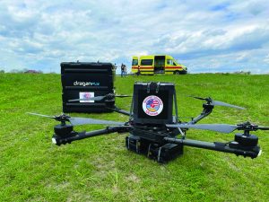
The platform consists of multiple drone products. The first one is a tethered or beyond line-of-sight drone that is deployed to a location at the same time as officers. The tethered drone can look at the area right from the station, whereas the beyond line-of-sight drone can arrive on scene before those dispatched personnel and provide situational awareness. As the team was developing the DFR, it became apparent that having a medical response drone (MRD) would also be advantageous. This second drone can provide up to 35 pounds of payload delivery, such as AEDs, Epinephrine, and blood, to the location. Because it is temperature-managed, the drone can also carry medical supplies that are temperature sensitive.
Both drones include an optical sensor that sends communications back to the operator in the dispatch center. They have between 30–50 minutes of run time depending on the payload, with an effective one-way distance of about 10km.
According to CEO Cameron Chell, the MRD has been deployed into besieged areas to provide medical supplies—primarily insulin and antibiotics—for those in need.5
Counter Defense
In 1984, the U.S. Congress passed the Aircraft Sabotage Act that states that it is illegal to willfully damage or destroy an aircraft; the FAA Modernization
and Reform Act of 2012 was passed, directing the FAA to integrate unmanned aircraft systems (drones) into the national airspace by September 2015.
This, however, introduced a threat to U.S. and public security. Congress’ Preventing Emerging Threats Act of 2018 tackled this issue by making it legal for the federal government to disrupt drones. The 2022 proposition of the Domestic Counter-Unmanned Aircraft Systems National Action Plan is a request from the Biden administration to change the law so that the same authorities granted to the federal enforcement agencies can be given to state and local police to detect and defeat dangerous drones.6
But if this passes through the U.S. Congress, how can state and local police stop these drones in a safe way in an urban environment? The Pleasant Grove, Utah–based Fortem Technologies believes it can help.
“We believe in smaller systems where you put the processing on the edge at each radar, and you aggregate the data in the cloud,” said Timothy Bean, chief executive officer at Fortem Technologies. The company backs this claim up through its family of TrueView radars, SkyDome Manager software, and DroneHunter, which can work separately or as a team.7
With this family of small radars, the company explains that an agency can see all drones in its area—whether emitting GPS or radio frequencies. This family is scalable and adaptable to the department’s needs. For example, one radar can be placed at a small entertainment venue, or hundreds can be placed throughout a city. By offering 360-degree coverage of an airspace, an agency can have complete situational awareness of where a potential drone target is at. The inclusion of the TrueView camera allows operators a high-resolution view to track and zoom in on what a radar has detected.
All the data acquired through the radars are aggregated within the SkyDome Manager software. The software also allows users to set specific rules around 3D, volume-metric exclusion zones throughout the city.
When an emerging threat enters the airspace, the SkyDome Manager and TrueView radars will communicate the threat’s location to the DroneHunter. If the targeted drone is smaller and slower than the DroneHunter, the DroneHunter will tether it with a net; but if the target is larger and faster, then the DroneHunter is programmed to get between its defense point and the targeted drone. It will then attach a parachute to it. Once it returns to its hangar, the DroneHunter will be once again mission-ready within three minutes.
Finding the Right Solution for You
As more drone uses are introduced into the law enforcement field, agencies may need help in choosing which solutions would be the best fit for them. Adorama Business Solutions and Adorama Drones have built a full-service drone ecosystem to serve as a one-stop shop for agencies and organizations looking to take advantage of UAS technology.
The Adorama Drone Ecosystem is a suite of services designed to help agencies and organizations leverage drone technology in a sustainable way. It consists of hardware and software solutions, buy-back programs, drone insurance, financial assistance, training, and repairs. Additionally, Adorama has in-house experts who have started drone programs in their own departments, offering knowledge and experience when it comes to ideating, launching, and maintaining a drone program for public safety operations.
“We know launching a program is no small feat, and the Adorama Drone Ecosystem is designed to help agencies through the process, answering questions and providing expert advice and recommendations along the way,” said Smith.
Drones have revolutionized the policing profession, and new functions for these vehicles arise every day. It is imperative for innovation to continue driving companies to create equipment that will help keep officers and the communities they serve safer.d
Notes:
1Federal Aviation Administration, “Drones by the Numbers,” May 31, 2022.
2CJ Smith (category marketing manager, Adorama Business Solutions), email interview, May 6, 2022.
3Tommy Gunn (marketing manager, Autel Robotics), email interview, May 15, 2022.
4Autel Robotics, “EVO LITE Series-Overview,” and “EVO NANO Series-Overview.”
5Cameron Chell (chief executive officer, Draganfly), telephone interview, May 13, 2022.
6The White House, “The Domestic Counter-Unmanned Aircraft Systems National Action Plan,” Fact Sheet, April 25, 2022.
7Timothy Bean (chief executive officer, Fortem Technologies), telephone interview, May 4, 2022.
|
SOURCE LIST Please click on the companies’ names to go to their websites or visit the Police Chief Buyers’ Guide to request information from companies. |
||
|
|
|
|